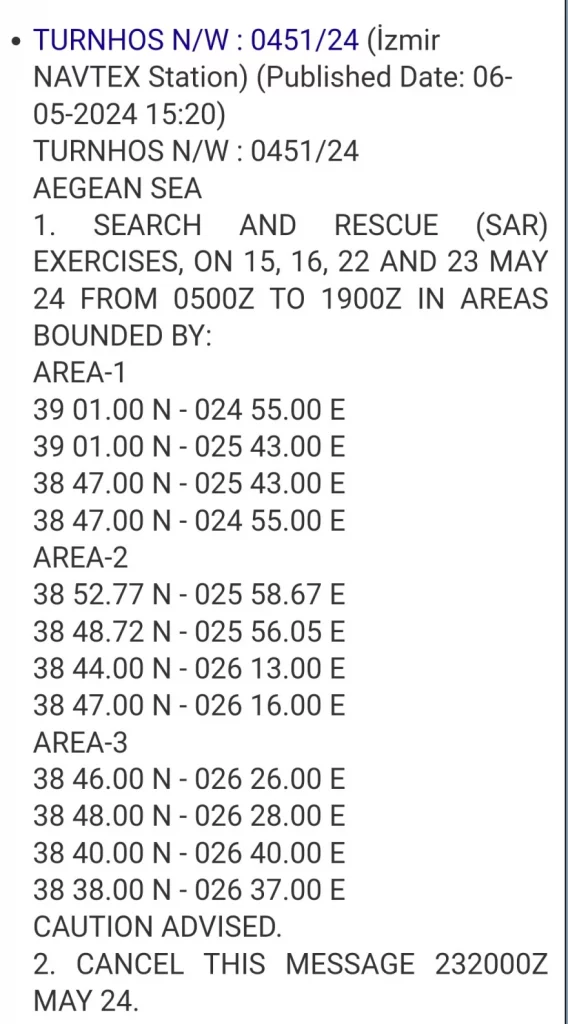
The latest provocation by official Turkey came with the issuance of a Navtex on Monday staking off three maritime regions in the central and eastern Aegean for “search and rescue exercises (SAR)”, with coordinates showing locations just beyond six nautical miles of several Greek isles but dozens of miles from the nearest Turkish coast in the case of the largest region.
The Navtex 0451/24, issued by a hydrography station in Izmir, announced that SAR exercises will be held on May 15, 16, 22 and 23.
The latest Turkish Navtex aims to again dispute Greece’s SAR zone – as recognized by international organizations – in the middle of the Aegean and with a bevy of Greek isles closer to every region cited than the Asia Minor coast. Athens has long viewed such provocations as attempts by the Turkish side to draw an imaginary line down the middle of the Aegean in order to isolate numerous Greek isles within Turkish zones of jurisdiction – a development that would mean a loss of sovereignty.
The dates cited in the Turkish Navtex come before a meeting in Ankara on Monday between visiting Greek Prime Minister Kyriakos Mitsotakis and Turkish President Recep Tayyip Erdogan.