“The water appeared at night. It silently entered the streets, courtyards, and fields. As if following a familiar, carved path. By morning, it had covered everything. The residents said they do not remember anything similar in recent years.”
This description does not depict a specific real event. However, it could have occurred in countless locations across Greece at any time in the last 140 years.
Indeed, from 1886 to the present, approximately 2,000 floods have been recorded, according to a study by a scientific team at the University of Athens (EKPA). In the past twenty years, these events appear to be increasing in frequency. Some attribute this to climate change and extreme weather events, others to human interventions in the landscape, and still others to state responsibilities. All explanations are valid.
However, scientists know that floods do not come… uninvited. They return to places that the landscape “remembers.” Floods have geographic patterns, seasonality, and repetition. They follow rivers, riverbeds, and plains, but are influenced by human interventions and encroachments.
New Digital Platform
Today, a new digital platform from the University of Athens (EKPA) maps, for the first time with scientific accuracy, 140 years of Greece’s flood history, showing that water, unlike humans, does not forget. From the late 19th century to today, according to the collected data, water has repeatedly covered plains, overflowed rivers, and traversed cities and villages. Yet never before have flood episodes been recorded as frequently, intensely, or destructively as in the last two decades. The question is no longer whether we will experience floods again, but where and when. The crucial issue is whether the state—and alongside it, its citizens—will be prepared.
Rain Is Not Always to Blame
Rain is not always the sole culprit. Areas flood not only during extreme rainfall, but sometimes because rain is infrequent. Flooding occurs in regions where rivers once flowed but have now been “erased” by concrete roads, as well as in areas built upon previous flood deposits.
Today, EKPA’s scientific team offers an interactive digital tool that precisely maps high-risk areas. It can be used by other scientists for research, by citizens for information, and most importantly by civil protection authorities for prevention and effective planning of essential works to mitigate future risks.
“Decision-makers must focus not only on areas at risk, but also on those where human lives and extensive damage to buildings, infrastructure, and property are threatened,” emphasizes Professor Niki Evelpidou of EKPA’s Department of Geology and Geoenvironment, a full member of the European Academy of Sciences and Arts.
The platform is based on an extensive database developed by EKPA researchers (Anna Karkani, Giannis Saitis, Kostas Filippopoulos, Evangelos Spyrou, and Alexandros Liaskos), coordinated by Professor Evelpidou and scientifically supported by Professor Konstantinos Kartalis.
Soil and Vegetation
The data reveal a less obvious truth. Analysis shows that extreme weather events leading to floods often follow extended dry periods, heavily affecting areas prone to drought, such as the eastern coastal regions and Aegean islands.
“The historical geographic distribution of floods clearly shows that Eastern Greece (east of the Pindus mountain range) is more affected, even though western areas receive higher annual rainfall,” says Professor Evelpidou. The explanation lies in soil and vegetation.
“When it rains throughout the year, vegetation regenerates, and tree roots slow surface runoff, as in Western Greece. In Eastern Greece, where rainfall is rare, soils dry out and cannot absorb water efficiently. As a result, water flows over dry soil almost like over asphalt.”
For the islands, the size of the island also plays a crucial role. “On a large island, water travels farther to reach the sea and may be temporarily retained in depressions, absorbed by the soil, or delayed. On smaller islands, e.g., in the Central Aegean, the distance from the mountain top to the sea is very short. Nature cannot retain the water, and low-lying areas flood,” she notes.
Rivers Disappear
No rule, however, is absolute. Island size alone does not determine flood risk; other factors such as rainfall intensity and terrain shape contribute. Human interventions also disrupt natural watercourses, creating flood hotspots nationwide.
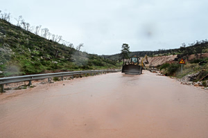
“You see a river starting from the mountain and then disappearing. Where it once flowed now stands a building. In a sudden heavy rainfall, all the water will flow toward the building. It has nowhere else to go. Water has memory,” the professor emphasizes.
On the mainland, EKPA’s historical data processing highlights a strong link between floods and major river systems, such as Pinios, Strymonas, Evros, and Spercheios, whose wide riverbeds and plains encourage overflow.
Flash floods in small mountainous basins are equally dangerous, as water rushes down in minutes after intense storms. Regions experiencing heavy floods include Macedonia and Thrace. Historical data show an increasing trend, leaving little room for complacency.
“Rainfall patterns have changed in recent years. The intensity of extreme events has increased. In one event, a third of the annual rainfall for an area may fall within hours. It is impossible for a region to cope with such heavy rain in such a short time. We saw this with the recent Byron storm, which was not even truly extreme,” notes Professor Evelpidou.
High-Risk Areas
In any case, the “red zones” for floods are well-known to the scientific community. “Geologists know where the next flood will occur. We don’t have prophetic abilities. It will happen where it always happened. It’s no secret. For example, plains formed by repeated floods, like the Thessalian Plain affected in 2023, are predictable,” she explains.
“What has changed over the years is that settlements, roads, and bridges have been built on fertile plains that attracted humans. Narrow crossings during heavy floods are insufficient for water and sediment to pass. Today, few things can be changed. Relocating a town like Mandra is utopian. But appropriate protective works can be designed and constructed.”
A “Gift” with Two Sides
Beyond the plains, Greece’s steep terrain also creates flood risk. “The beautiful relief is a gift from the country’s seismicity. But it also brings steep slopes that accelerate surface runoff. In the past, people built terraces to cultivate steep land. These terraces held soil and slowed water flow,” notes the research coordinator.
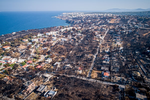
Now, in tourist areas, abandoned land restores steep slopes, causing soil to wash away with each rainfall, creating mudflows that lead to destructive floods in lower areas. “Upland soil is lost, vegetation cannot regenerate, and a vicious cycle begins,” she stresses.
The future is not reassuring. Although most consider earthquakes Greece’s greatest risk, “floods are and will remain the number one natural disaster in the Mediterranean and Greece,” says Professor Evelpidou, as rainfall patterns continue to change.
In the Eye of the Storm
Greece is at the center of a flood hotspot. “The country possesses all characteristics that lead to flood risk: steep relief, rainfall patterns, prolonged droughts, lack of vegetation, wildfires, and societal issues like unplanned construction and other interventions,” she emphasizes.
Regarding seasonal flood distribution, EKPA data show that autumn is the most dangerous period. “We knew this empirically; now statistical analysis confirms it. More than half of floods (52%) occur in autumn, with October and November accounting for nearly 40% of flood events over the past 130 years. January, December, June, and other months follow at lower levels,” concludes Professor Evelpidou.
The University of Athens’ digital portal (https://historicfloods.org) presents historical flood data with interactive maps. It is dynamic, continuously updated with new data and evolving tools. For governmental bodies (ministries, regions, municipalities, etc.), the platform can function “à la carte,” providing information tailored to decisions for specific areas under defined conditions.