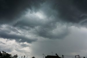
Greece is facing another day of intense storms and flooding, after torrential rain swept through parts of the country on Sunday, turning streets into rivers and damaging homes and vehicles in several regions.
The Ionian coast and Epirus were hit hardest, with particularly heavy downpours in Preveza, Corfu, and Filippiada, where residents endured hours of lightning and thunder that left roads submerged and local authorities struggling to manage the damage.
Roads Turn to Rivers in Preveza
In the city of Preveza, streets quickly flooded as water overwhelmed drainage systems. The Fire Service received dozens of calls for help and had to pump water from basements and semi-basements in multiple neighborhoods.
Emergency crews also cleared fallen trees brought down by strong winds, while municipal workers in Filippiada used heavy machinery to restore access to the city’s main road after it became impassable.
Residents reported blocked drains and rising water levels, but authorities said the overall extent of damage was limited given the severity of the storm.
Meteorologists, however, have warned citizens to remain cautious, as rain and thunderstorms are expected to continue through Monday afternoon.
Wall Collapse in Corfu
The storm also struck the island of Corfu, where a retaining wall collapsed in the Padova area, crushing a parked car beneath debris. The incident occurred shortly after 6 p.m. on Sunday behind the local sports club.
The vehicle sustained significant damage, but no injuries were reported, as the car was unoccupied at the time. Local residents told reporters that the wall had shown signs of wear for some time, yet no preventive repairs were made.
Municipal crews closed the road for an hour to remove rubble and ensure the area was safe.
Damages Reported in Thessaloniki
In Thessaloniki, Greece’s second-largest city, the storm caused two trees to fall, damaging parked cars in separate incidents early Monday morning.
One tree fell onto a vehicle in the city center around 5 a.m., while another came down in the Depot district, again causing material damage but no injuries.
Storms Continue Across the Country
According to the National Observatory of Athens (Meteo), the weather front remains active, bringing heavy rain, thunderstorms, and possible hail across western and northern Greece.
The rainfall event has been categorized as Level 3 (Significant) on the Regional Precipitation Index, indicating the potential for localized flooding and infrastructure damage.
Strong storms are expected in Epirus, the Ionian Islands, Western Greece, Macedonia, and Thrace, with the possibility of short but intense hailstorms in some areas.
In Athens, residents can expect cloudy skies and scattered thunderstorms, especially in the afternoon. Winds will remain moderate, and temperatures are forecast between 18°C and 21°C (64°F–70°F).
In Thessaloniki, intermittent rain and mild thunderstorms are likely, with temperatures from 15°C to 20°C (59°F–68°F).
Despite the unsettled weather, a slight rise in temperatures is expected in the southern islands, where winds could reach up to 6 Beaufort in the seas.
Authorities Urge Caution
Authorities continue to urge citizens to avoid unnecessary travel in flood-prone areas and to report blocked drains or fallen trees to emergency services.
Meteorologist Giorgos Tsatrafilias warned in a post that the current cycle of storms could last up to 40 hours, with the most intense phase expected through Monday evening.
While the rainfall is forecast to ease gradually, localized flooding and disruptions may persist for several days.