Severe weather is affecting large parts of Greece, bringing heavy rain, thunderstorms, strong winds, and snowfall, the Hellenic National Meteorological Service (EMY) said in its latest forecast.
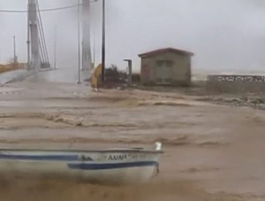
Powerful storms struck parts of the eastern and southern Aegean from the early morning hours, hitting islands including Chios, Samos, Ikaria, the Dodecanese, and areas farther south such as Rhodes, Kastellorizo, Karpathos, Kasos, and Crete. The weather service warned that the phenomena could be locally intense but said conditions are expected to gradually weaken from midday onward.
On Crete, especially in the western and southern parts of the island, heavy rain and thunderstorms are set to persist into the early morning. Southern Evia and parts of the northern Cyclades also saw brief but strong storms earlier in the day. Across the eastern Aegean islands and the Dodecanese, rough weather is forecast to last until around midday before easing later in the afternoon.
Meanwhile, winter conditions prevail in northern mainland Greece. Snowfall is occurring in mountainous and semi-mountainous areas of eastern Macedonia and Thrace, in some places falling heavily. In parts of Thrace, snow may reach even low-altitude areas through midday.
Elsewhere in the country, conditions are milder. Several central and eastern mainland areas are seeing variable cloud cover with limited rainfall and no significant weather impacts expected.
In the capital region of Attica, forecasters expect partly cloudy skies with occasional thicker cloud cover and a slight chance of brief light drizzle. Temperatures range between 7 and 15 degrees Celsius.
Thessaloniki is experiencing local rain showers, with temperatures between 5 and 12 degrees Celsius. Southeasterly winds in the surrounding gulf area reach 2 to 4 Beaufort, locally up to 5.
Winds across the country generally blow from northern directions at 4 to 6 Beaufort, while southeastern areas see westerly winds of similar strength. In the Aegean Sea, winds reach up to 7 Beaufort in places but are forecast to gradually weaken from the north. Temperatures are dipping slightly in central and southern regions but remain near seasonal averages. Frost is expected in parts of the central and northern mainland during the morning and night.
Looking ahead to Tuesday, forecasters expect partly cloudy skies with occasional increases in cloud cover and a chance of light local rain in parts of central Macedonia, the Sporades, the Cyclades, and the Dodecanese during the morning. Light snowfall is possible in northeastern mountainous mainland areas early in the day. Temperatures will rise slightly in maximum values, though frost will still occur in central and northern mainland areas during the morning and evening.
On Wednesday, cloud cover will increase at times, bringing local rain to central Macedonia and, later in the day, to western areas and gradually to the rest of Macedonia and Thessaly. Overnight, rain is expected to spread to most mainland regions and parts of the central and northern Aegean, with isolated thunderstorms possible in the northern Ionian Sea and potentially in Epirus. Light snowfall may occur in northwestern mountainous areas late in the evening. Temperatures are forecast to rise further.