A heat wave will affect several parts of Greece on Monday, August 24, with temperatures locally climbing as high as 42°C (108°F). Showers are also expected in mountainous areas of mainland Greece during the hottest part of the day.
In Attica, temperatures are expected to reach 40°C (104°F), while authorities remain on alert for wildfires, with 11 regions placed under a Red Code warning.
The forecast
More specifically, sunny conditions with a few clouds are initially expected across the country. Around midday, cloud cover will increase over mainland areas, bringing showers or isolated thunderstorms to mountainous areas. Heat wave conditions are expected in some areas, while minimum temperatures will remain high in urban centers overnight.
Temperatures in Western Macedonia will range from 16°C to 34–35°C (61–95°F), while in the rest of Macedonia and Thrace they will range from 16°C to 36–37°C (61–99°F), locally reaching 38–39°C (100–102°F). In Thessaly, temperatures will range from 17°C to 37–39°C (63–102°F), potentially reaching 40°C (104°F) locally. In Epirus, they will range from 17°C to 35–37°C (63–99°F).
In the rest of mainland Greece, temperatures will range from 18°C to 37–39°C (64–102°F), locally reaching 40–42°C (104–108°F) in eastern and southern areas. Temperatures in the Ionian Islands will range from 20°C to 35–36°C (68–97°F), while in the islands of the Aegean Sea and Crete, they will range from 19°C to 33–35°C (66–95°F). Maximum temperatures will locally reach 38–39°C (100–102°F) on the islands of the eastern Aegean and in southern Crete.
Northerly winds will blow across the Aegean at 4–5 on the Beaufort scale, locally reaching 6, while northwesterly winds of up to 5 on the Beaufort scale will prevail in the Dodecanese. Northwesterly winds of 3–4, locally reaching 5 on the Beaufort scale, will blow across the Ionian Sea.
Weather in Attica and Thessaloniki
In the Attica region and the city of Athens, sunny conditions are expected, with localized cloud cover developing after midday. Northerly to northeasterly winds will blow at 3–4 on the Beaufort scale, increasing to 5–6 in eastern parts of the region. Temperatures will range from 28°C to 38°C (82–100°F), potentially reaching 40°C (104°F) locally across the region.
In the Thessaloniki region and city, a few clouds are expected, increasing over mountainous areas after midday. Winds will be light, shifting to southerly to southeasterly at 3–4 on the Beaufort scale during the hottest part of the day. Temperatures will range from 25°C to 35°C (77–95°F).
Red Code for 11 regions
The following areas have been placed on Red Code alert today:
- The Attica region, including the island of Kythira
- The regional units of Phthiotis, Boeotia and Evia, including the island of Skyros, in the Central Greece region
- The regional units of Corinthia, Argolis and Laconia, in the Peloponnese region
- The regional unit of the Cyclades, in the South Aegean region
- The regional units of Lesbos, Chios, Samos and Ikaria, in the North Aegean region
According to the team responsible for issuing the General Secretariat for Civil Protection’s Daily Fire Risk Forecast Map, the fire danger in these areas is expected to be very high, at risk category 4.
Discomfort on Sunday night
High temperatures, locally reaching 33°C (91°F), were recorded late on Sunday night, August 23, across many parts of the Attica region and particularly in Athens, as shown on the map below.
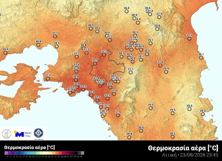
Map 1: Temperatures across the Attica region and Athens late Sunday night, August 23
These temperatures, combined with high relative humidity levels, created conditions of significant heat discomfort, as shown on Map 2.