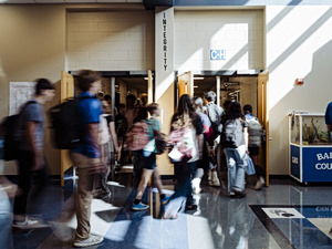
Starting today, damage assessment teams have begun inspecting properties in Porto Germeno affected by the destructive fire, marking a key step toward recovery for those impacted.
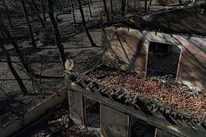
A drone view shows a burnt house after a wildfire in Porto Germeno, Greece, August 3, 2026. REUTERS/Stelios Misinas
Teams have been on site since early morning, beginning inspections of the affected properties. Also present are the Minister of Climate Crisis and Civil Protection, Evangelos Tournas, along with local government representatives.
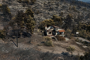
A drone view shows a burnt house after a wildfire in Porto Germeno, Greece, August 3, 2026. REUTERS/Stelios Misinas
Engineers will conduct house-by-house inspections, recording the extent of damage to homes and property. The results will determine whether homes are habitable, need repairs, or have suffered irreparable damage.
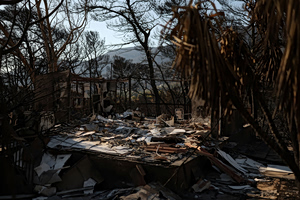
A burnt house after a wildfire in Porto Germeno, Greece, August 2, 2026. REUTERS/Stelios Misinas
The process is considered decisive, as it will form the basis for compensation payments.
The situation in Porto Germeno remains difficult, with burned homes and damaged property, as residents continue to take stock of their losses.
The fire that changed Porto Germeno forever
The large wildfire that swept through western Attica has completely altered the appearance of the Porto Germeno bay.
Drone footage from the Orange Press Agency shows that the flames left only a few patches of greenery in their wake, turning the once-lush area into a mountain of ash. Dozens of homes in the wider area, mainly in Aspra Spitia and Prosili, were completely destroyed, while others suffered damage. In some spots, the fire appears to have spared certain buildings entirely, leaving an untouched house standing across from a ruined one.

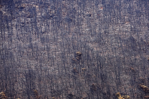
On the slopes toward Kithaironas, the scene is heartbreaking: where countless trees once stood, only their charred remains and shadows are left.
Starting today, according to an announcement from the Municipality of Mandra-Eidyllia, on-site inspections of properties affected by the Porto Germeno fire.
The inspections will be carried out by teams from the General Directorate for the Restoration of Natural Disaster Effects (GDAEFK) under the Ministry of Climate Crisis and Civil Protection, and represent an essential step in officially recording and assessing the damage as part of the standard recovery procedures. The Municipality of Mandra-Eidyllia is asking fire-affected residents to be present at their properties during the inspection to ensure teams have access and can receive any necessary information. As the municipality noted, “timely and accurate recording of the damage is a decisive step for speeding up the support and recovery procedures for those affected.”
Grief from images of the burned properties
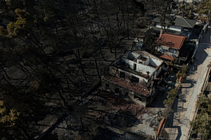
A drone view shows burnt houses after a wildfire in Porto Germeno, Greece, August 3, 2026. REUTERS/Stelios Misinas
The first light of day reveals the true scale of the destruction left by the wildfire. Extensive burned areas, destroyed properties, and a landscape resembling ash and embers make up the scene facing residents and assessment crews.
Streets that just hours earlier were at the center of the battle against the flames are now filled with charred trees, deformed structures, and traces of the firestorm. Residents are gradually returning to their properties to assess the damage.
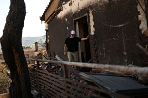
Vivi Gialia, 45, walks in front of her burnt house after a wildfire in Porto Germeno, Greece, August 3, 2026. REUTERS/Stelios Misinas
Images taken the following day capture, in the starkest way, the intensity of the fire’s path. At the same time, they highlight the difficult recovery work ahead and the challenge of restoring normal life to the affected areas.
The photo coverage documents a reality in which ash has covered every trace of life. Residents’ anguish is now turning into an effort to rebuild and start over.
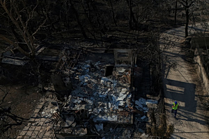
A drone view shows a burnt house after a wildfire in Porto Germeno, Greece, August 3, 2026. REUTERS/Stelios Misinas
Panagiotis Margetis, mayor of Megara, told MEGA: “At the points where the hot spots were, the trunks are smoldering, small flare-ups can probably still start there. For helicopters to fly, it’s still certainly dangerous for flare-ups, so I hope this will be the next day, that all this will be over. But you understand, drops are still being made as a precaution.”
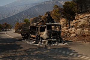
The remains of a burnt fire truck on a road after a wildfire in Porto Germeno, Greece, August 3, 2026. REUTERS/Stelios Misinas
He added: “It’s not yet time for precise calculations of the damage. What I can tell you in general terms is that we have, I’m speaking for my municipality, around 25,000 stremmata of forest that have burned. (…) There is also damage to crops, thousands of stremmata of crops, olives, pistachios, vegetables have been completely burned or their infrastructure has, and livestock businesses.”
“We are taking stock of the wounds”
Kostas Tsigkas, president of the Union of Fire Service Officers, said regarding the fronts: “No force has withdrawn from here. The aerial units approached the fire area, drops are being made across the entire perimeter. The aerial forces have focused, following indications from the ground units, on the area of Loumba. The other part is in the northern part of Psatha and in the area of Villia, on the lower side there at Agios Nektarios, there is a spot that is still smoking.”
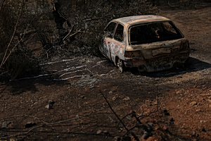
The remains of a burnt vehicle after a wildfire in Porto Germeno, Greece, August 3, 2026. REUTERS/Stelios Misinas
He added: “It also appears, from the point of view of the whole fire, which is being monitored by fire service forces, that there is no problem at this moment and that this fire will soon be contained. However, the forces here will remain for many more days.”
On the Boeotia front, Stathis Kefalas, president of Xironomi, noted: “Here the front was different from the one at Agios Vasileios, where the fire then moved toward Porto Germeno. Now we are looking at the next day, we are taking stock of the wounds, the recording of the damaged buildings has already begun.”
He concluded: “The damage we have in our village is around 20,000 olive trees. In the neighboring village it’s around 50,000 olive trees. Beyond the forest area, which I cannot specify, thousands of stremmata have burned.”
Shocking scale of the destruction
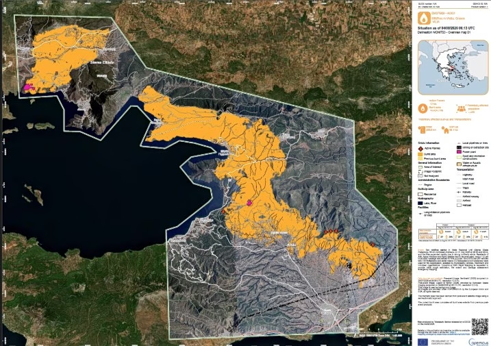
The scale of the disaster is reflected in the latest data from the European Copernicus service, based on satellite images taken on the morning of August 4.
According to the latest estimate, the fire has destroyed a total of 144,243 stremmata (35,643 acres) of land, leaving behind a massive footprint of destruction. Of that, 30,966 stremmata (7,651 acres) are in Boeotia, in the Xironomi area, while the remaining 113,277 stremmata are in the Porto Germeno area, on the border between Attica and Boeotia.
The images left behind by the firestorm are striking. Entire forested areas have turned to ash, vegetation has been almost completely destroyed in many spots, and the landscape resembles a wasteland. The satellite photos capture the enormous scale of the destruction, with black covering thousands of stremmata that just days ago were full of green.
On alert for flare-ups
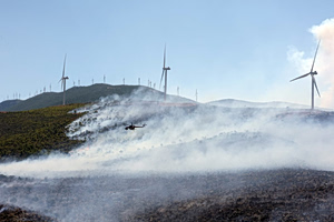
Fire crews are still “fighting” to put out the last scattered hot spots of the fire that broke out in Boeotia and spread into Attica.
At first light, four helicopters began drops, focusing on smoking areas. The latest front is in the Loumba area.
Fire service forces are not letting their guard down and remain strong, with forest commando teams operating on the mountain throughout the night.
In total, more than 500 firefighters, 29 ground crews, and 150 vehicles remain deployed.
The operation also includes 26 Romanian firefighters with five vehicles and 23 French firefighters with four vehicles, present in Greece under the pre-positioning program of the European Civil Protection Mechanism.