
A significant change in weather is set to affect Greece over the weekend, as a cold air mass—often referred to as a “cold pool”—moves in from Italy. This system is expected to bring a sharp drop in temperatures, widespread rain, thunderstorms, and even hail in some areas, marking a sharp contrast to the heatwave conditions leading up to Friday.
According to meteorologists, Friday will see temperatures soar locally to 38°C—about 5 to 6 degrees above the seasonal average. However, this summer heat will be short-lived. The incoming cold pool will disrupt atmospheric stability, leading to unsettled and potentially dangerous conditions across much of the country for about 48 hours.
The hallmark of this weather pattern is volatility. Skies may begin clear, only to suddenly turn cloudy and erupt into showers or storms, then clear again—repeating unpredictably throughout the day. The sporadic nature of these events makes it difficult to pinpoint precise timings.
High-Risk Areas
Forecast models indicate a heightened risk for severe weather in several regions: Macedonia, Epirus, Thessaly, the northern and western Aegean, and large parts of the Peloponnese.
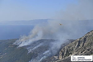
By Sunday, as the disturbance begins to dissipate, a significant pressure gradient is expected to form over the Aegean. This will likely generate strong northerly winds, potentially reaching gale force. While these winds will bring a drop in temperatures, they also raise the risk of wildfires due to dry conditions and gusty airflows.
Official Forecasts
Friday, June 20:
Clear skies will start the day nationwide, but cloud cover will increase over the mainland by afternoon, bringing scattered showers. Isolated thunderstorms are likely in Macedonia, Thrace, Thessaly, and mountainous parts of Central Greece and the Peloponnese. Northwest winds at 3–5 Beaufort will reach 6 in the eastern Aegean, shifting to northeasterly in the northeast by night, also up to 6 Beaufort.
Saturday, June 21:
Rain and isolated storms will affect Central Macedonia, the Sporades, Thessaly, and Evia, easing by afternoon. Elsewhere, skies will stay mostly clear, with brief afternoon clouds inland—mainly in Central Greece and the Peloponnese, where local showers or storms may develop. Northerly winds will reach 3–5 Beaufort in the west, 4–5 in the east, and up to 6–7 in the Aegean. Temperatures will drop by 3–5°C.