Greece will see a slight drop in temperatures over the August 15 holiday weekend, with strong northerly winds in the Aegean and the possibility of local showers and storms in some regions, according to forecasts
Athens will see maximum temperatures of 37-38°C, with a gradual cooling starting Wednesday. The ongoing winds are also causing cooler sea surface temperatures along the Ionian coast due to upwelling
Authorities warn of “extreme fire risk” on Sunday, with winds up to 90 km/h and temperatures near 40°C in parts of the country. Cooler conditions expected by mid-August holiday.
Temperatures are also rising steadily, with Western Greece expected to reach 38–40°C over the weekend. While the meltemi winds may keep eastern Greece slightly cooler (35–37°C), the fire risk remains elevated due to dryness and wind speed
Greece’s weather in August is proving to be as unpredictable as ever, with alternating spells of sunshine, rain, hail, and powerful seasonal winds known as meltemia.
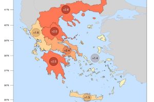
The average daily maximum temperatures across the country exceeded the seasonal norm, as measured against the 2010–2019 average.
It is also reminded that during the official fire season, the burning of fields is strictly prohibited. Anyone who spots a fire is urged to immediately contact the Fire Department by dialing 199
According to the National Observatory of Athens’ meteo.gr platform, the combination of high temperatures, atmospheric dryness, and strong winds could create dangerous conditions for wildfires across much of the country from Sunday, July 13
From Sunday, July 13, Greece will once again face elevated temperatures and persistent heat, potentially putting additional strain on public health and infrastructure
The heat is also pressing down on Attica, where temperatures are climbing to 35°C.
Public health officials continue to emphasize the dangers of prolonged heatwaves, often described as "silent killers."
Forecasters warn of a second, more intense heatwave expected over the weekend, though early predictions suggest it will be short-lived.
Travelers should stay hydrated, avoid outdoor activities during peak afternoon hours, and monitor local forecasts if planning to visit islands where strong winds might impact ferry services or beach conditions
According to the National Meteorological Service (EMY), today's temperatures will fall by 2 to 3 degrees Celsius, and by Sunday, June 29, the mercury is not expected to exceed 32 to 34°C across most areas.
This heatwave is being driven by warm air masses moving across the Mediterranean and parts of Europe, with temperatures at 1,500 meters above sea level measuring 10–12°C above normal
Tuesday will be an ideal summer day across Greece, with plenty of sunshine, high temperatures, and light to moderate winds—excellent weather for beachgoers and travelers
The latest weather bulletin by the Hellenic National Meteorological Service (ΕΜΥ) warns of a sharp shift starting midday Friday, with strong thunderstorms and winds expected in Northern Greece and mountainous areas of Central Greece and the Peloponnese, while the phenomena are forecast to spread further on Saturday
A drop in temperatures, strong winds, and local storms are forecast as two weather systems move into the country.
To overcome these institutional limitations, the government is considering the creation of 45 new corporate entities — one for each of Greece’s river basins or designated regions.
These projections align with a broader trend across Europe, where above-average temperatures are expected continent-wide