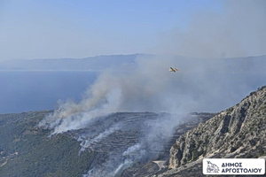
Greece faces a sudden shift in weather on Friday, June 27, as the National Meteorological Service (EMY) issues an emergency warning. Intense storms, heavy rain, and violent winds are expected to hit parts of the country, even as a heatwave continues. Experts warn the extreme conditions could heighten wildfire risks.
According to the emergency bulletin, high temperatures will persist through Friday, June 27. However, from the afternoon onward, northern parts of the country are forecast to experience scattered strong thunderstorms, accompanied briefly by powerful winds—typical signs of summer squalls.
Temperature Outlook
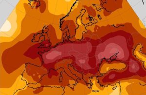
Today’s temperatures are expected to peak between 39°C and 41°C in mainland Greece, and between 36°C and 38°C on the islands. A gradual drop is anticipated starting Saturday, with a 2–3 degree decline. By Sunday, June 29, temperatures will range from 32°C to 34°C.
Storms in the North
Severe thunderstorms are forecast to develop this afternoon across Western and Central Macedonia, extending into Eastern Macedonia and Thrace by nightfall. These conditions are expected to subside by early Saturday morning.
Winds Strengthening Nationwide
Starting Saturday, wind intensity will gradually increase across the country. By Sunday, winds are projected to reach up to 9 on the Beaufort scale in the Cyclades, Crete, the Dodecanese, and the Eastern Aegean islands, and up to 8 Beaufort in Euboea, Attica, and parts of eastern Peloponnese.
Meteorologists highlight the risk posed by today’s storms, especially in northern regions moving into the night and early morning hours. Unstable weather is expected to return again by Saturday afternoon.
Apart from the direct hazards of thunderstorms and high winds, experts warn that the extremely low surface humidity may significantly elevate the risk of fires being sparked during storm activity.