Turkey on Monday replied with a “tit-for-tat” publication of its own map in what most analysts had predicted would follow Greece’s officially stated intent to designate a marine protected area park in the south Aegean Sea – a process expected to commence this month.
Ankara, in fact, conveyed its own version of a marine uses map in the eastern and central Aegean, among others, to UNESCO, maintaining that the next step will be to notify the United Nations, the body where such maps by sovereign nations are submitted.
The unveiled map essential “cuts” the Aegean in two, echoing the long-standing – and exceptionalist – Turkish view of half the sea comprising its future continental zone, with the numerous Greek islands to the east of this imaginary line having no influence apart from the six nautical miles that surround them and are Greek territorial waters.
The latest example of “Turkography” displays a red line beginning from the Evros Delta on the Greek-Turkish land border in the Thrace province and continuing south down the Aegean to the south of the Dodecane islands – in essence delineating what Ankara claims as the “midpoint” between Asia Minor and the mainland of Greece.

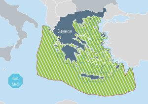
A copy of the proposed two marine parks by Greece, one in the Ionian Sea (left) and the other showing the portions to be included in the south Aegean Sea.
Turkey, which refuses to apply (de facto or de jure) the UN Convention on the Law of the Sea (UNCLOS) in the Aegean, has long claimed that the Greek islands have no geographical influence except for six nautical miles that surround them.
Another “highlight” of the Turkish map are diagonal lines in the eastern Mediterranean delimitating hydrocarbon exploration concessions awarded by the country’s state oil company (TPAO).
Additionally, Turkey maintains that it has the right of permanent military firing ranges in certain maritime regions, marked off in pink.
Finally, a black line that passes north of Crete, Greece’s largest island, and then continues north towards the Dardanelles in international waters is described as an undersea “cable”.
Athens’ reaction
In a reply a few hours later, Greece’s foreign ministry noted that “…Turkey today published a maritime spatial plan in response to a Greek plan, which is already part of the European acquis. The difference is that the Turkish map has no basis in international law, as it attempts to usurp areas of Greek jurisdiction, and is not addressed to an international organization that imposes an obligation to post such relevant maps.
“Therefore, it does not produce any legal effect and is simply a reflexive reaction of no substance. Greece will insist on its principled policy and calls on Turkey not to table maximalist claims, which everyone understands are for internal consumption only. Greece will take all appropriate action in international forums.”