
A NASA satellite captured a remarkable series of atmospheric phenomena over the Gulf of Alaska on the last day of astronomical winter, revealing in extraordinary detail the behavior of Arctic air as it moves across open ocean.
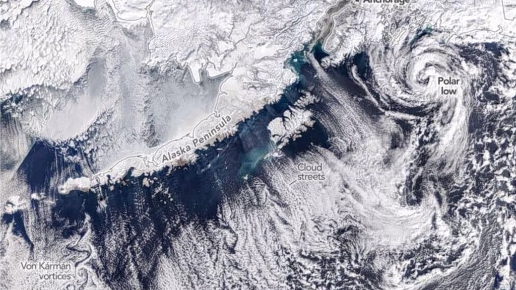
On March 19, 2026, NASA’s Terra satellite, equipped with the MODIS (Moderate Resolution Imaging Spectroradiometer) instrument, recorded an unusual concentration of cloud cover off the southern coast of Alaska. The resulting image captured several distinct meteorological phenomena simultaneously: organized cloud bands near the coastline, all the way to a dense storm system with near-tropical-force winds hundreds of miles offshore.
Arctic air meets warm water
According to a NOAA report issued the same day, a low-pressure system over the Gulf of Alaska, combined with a high-pressure system over eastern Russia and northern Alaska, pushed cold Arctic air southeastward. As the dry, freezing air passed over the warmer ocean surface, it absorbed heat and moisture, generating the characteristic cloud formations that were so clearly captured in the satellite image.
Close to the coast, the sky remained mostly clear, as the air had not yet accumulated enough moisture. A hazy band likely indicated sea fog. Further offshore, the air had gathered enough energy to produce what are known as “cloud streets”, long, parallel bands aligned with the wind direction. These form when rising warm, moist air masses create clouds while cooler air descends alongside them, leaving clear corridors in between.
Moving further across the gulf, the streets evolved into open-cell clouds, thin-walled formations enclosing circular open spaces. The progression from clear skies near the coast to increasingly organized structures further out is a textbook illustration of this atmospheric process, and the image is particularly notable for the clarity with which each stage is visible.
Von Kármán vortices and the polar low
Near Unimak Island, the easternmost of the Aleutian Islands, the image displays striking rows of von Kármán vortices, alternating, counter-rotating swirl formations that develop when wind is deflected around elevated terrain. This chain-like spiral pattern is rarely observed with such clarity.
One of the most remarkable features of the day was a large cloud swirl approximately 180 miles southwest of Anchorage. Meteorologist Matthew Cappucci identified the system as a polar low, a small but intense cyclone that forms when cold polar air moves over warm water. According to Cappucci, the system was accompanied by tropical-force winds and produced blizzard conditions and thunderstorms near its center — an unusual combination for a system of that size. Polar lows differ from typical mid-latitude storms in that they develop rapidly, are difficult to forecast, and pose real risks to maritime navigation.
A rare snapshot of the Arctic atmosphere
The conditions of March 19 were part of a broader pattern that had dominated the entire month. The University of Alaska Fairbanks reported that March 2026 was characterized by hazardous weather, with below-normal temperatures and repeated snowfall along coastal areas.
By late April, temperatures had risen, but the improvement proved temporary. According to Alaska’s News Source, Southcentral and Southeast Alaska faced renewed instability as an “atmospheric river” — a long, narrow corridor of concentrated moisture in the atmosphere — approached the region, extending what had already been a difficult winter.
The satellite image, created by Michala Garrison of NASA’s Earth Observatory using MODIS data from NASA EOSDIS LANCE and GIBS/Worldview systems, is considered one of the most comprehensive visualizations of simultaneous cloud phenomena in the region in recent years. For atmospheric scientists, it is a rare and striking example of cloud streets, cellular formations, island vortices, and a polar cyclone all coexisting within a single field of view.