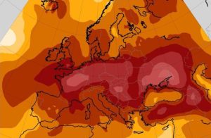
Greece is set to experience its first significant heatwave of the summer this week, as hot air masses from North Africa begin moving across the country starting Wednesday, June 25. Meteorologists warn that while the extreme heat will be relatively short-lived, it could push temperatures beyond 40°C (104°F) in several inland regions, before giving way to potentially severe thunderstorms over the weekend.
A Week of Weather Extremes
The early part of the week will be marked by milder summer conditions, with moderate heat and northern Aegean winds—known locally as meltemia—helping keep temperatures under control. However, from Wednesday onward, a dramatic shift in atmospheric circulation is expected to bring a surge of hot air across Greece, particularly affecting the mainland.
By Thursday and Friday, peak temperatures are forecast to reach 41°C (105.8°F) in several areas, including Thessaly, Kilkis, Serres, and parts of western Greece such as Aetolia-Acarnania.
Meteorologists: Not a Full Heatwave—But Still Dangerous
Despite the intense daytime highs, weather experts say the upcoming warm spell doesn’t quite meet the criteria of a classic kafsonas (heatwave) in Greece. Meteorologists explained that while afternoon temperatures will spike, nighttime cooling and steady meltemia winds across the central and southern Aegean will offer some relief.
“The short duration of this heat event—lasting between 48 and 72 hours—along with the nighttime temperature drop and persistent winds, mean we’re not technically looking at a full-blown heatwave,” said Tsatrafilias.
People should expect a “brief but powerful burst of heat” which will be intense but manageable, particularly for coastal regions and islands benefiting from strong sea breezes.
Fire Risk on the Rise
The combination of dry air, high temperatures, and gusty winds will elevate wildfire risks across much of the country, especially in forested and mountainous areas. Authorities are urging residents and tourists alike to avoid open flames, barbecues, or any outdoor activity that could spark fires during this period.
Weekend Storms Could Follow the Heat
As the week draws to a close, a new atmospheric disturbance moving in from Central Europe is expected to bring an abrupt end to the heat. Current models suggest this may result in thunderstorms—potentially severe—across several parts of the country over the weekend.
While forecasts remain uncertain, early indicators suggest these storms could be intense, particularly in northern and central regions, where cooler air masses will clash with the lingering heat and humidity.